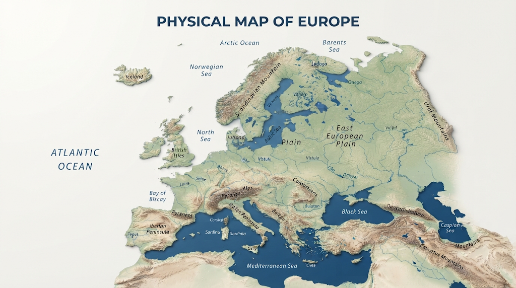
A physical map of Europe provides a visual picture of the continent’s natural landscape, including mountains, plains, rivers, lakes, seas, plateaus, valleys, and other important landforms. Unlike a political map that focuses on countries and borders, a physical map helps readers understand how Europe is shaped by nature.
Europe is often described as a peninsula of peninsulas because of its extensive coastline and numerous projecting landforms. It stretches from the Atlantic Ocean in the west toward the Ural Mountains in the east and from the Arctic region in the north to the Mediterranean region in the south.
Studying a physical map of Europe is useful for students, travelers, researchers, teachers, and anyone interested in geography. It makes it easier to understand why certain regions have particular climates, rivers, agricultural areas, cities, and transportation routes.
What Is a Physical Map of Europe?
A physical map of Europe is designed to show the natural features of the continent rather than political boundaries. Different colors, shading, contour patterns, and labels are commonly used to represent elevation and terrain.
Mountain ranges may appear in darker or raised shades, while low-lying plains are often shown with lighter colors. Rivers and lakes are normally displayed in blue, allowing users to quickly identify Europe’s major freshwater systems.
Physical maps can also show coastlines, islands, peninsulas, plateaus, valleys, seas, and other geographic features. This makes them particularly useful when learning how Europe’s natural landscape varies from one region to another.
Major Physical Regions Shown on a Physical Map of Europe
A physical map of Europe reveals a remarkable variety of landscapes. National Geographic broadly divides Europe’s major physical regions into the Western Uplands, North European Plain, Central Uplands, and Alpine Mountains.
Western Uplands
The Western Uplands extend around parts of western and northern Europe. They include areas of Scandinavia, Iceland, Ireland, Scotland, Portugal, and Spain.
Ancient rocks and glacial activity have played an important role in shaping this landscape. In Scandinavia and Iceland, glaciers helped create dramatic valleys, lakes, and fjords. The Norwegian coastline is particularly famous for its deep fjords surrounded by steep mountains.
When viewing a physical map of Europe, these northern and western highlands help explain why the landscapes of countries such as Norway, Sweden, Iceland, Ireland, and Scotland can look so different from the flatter areas of central Europe.
The North European Plain
One of the most important features visible on a physical map of Europe is the North European Plain. This broad lowland region stretches across much of northern Europe toward Russia.
The plain includes parts of France, Belgium, the Netherlands, Germany, Denmark, Poland, the Baltic states, and Belarus. Much of it has relatively low elevation and contains major river systems, fertile soils, and extensive agricultural areas.
Its flat terrain has also historically encouraged transportation, farming, settlement, and trade. Rivers such as the Rhine, Elbe, Oder, and Vistula are especially important geographic features of this region.
Central Uplands
Between Europe’s northern lowlands and southern mountain systems are the Central Uplands. These areas include highlands and wooded terrain across parts of France, Belgium, Germany, Czechia, Switzerland, and Austria.
The Central Uplands are generally lower and less rugged than the Alps. Features such as the Ardennes, Black Forest, Vosges, and Massif Central demonstrate the variety of terrain found across central Europe.
A detailed physical map of Europe makes these transitional landscapes easier to recognize because they sit between major plains and higher mountain regions.
Alpine Mountain Region
The southern part of Europe contains some of the continent’s most impressive mountain ranges. The Alps are the best-known example, extending through several countries including France, Switzerland, Italy, Austria, and Slovenia.
Other important mountain systems include the Pyrenees, Apennines, Carpathians, Dinaric Alps, Balkans, and Caucasus. These mountain ranges strongly influence climate, transportation, rivers, agriculture, and settlement patterns.
Mount Elbrus in Russia’s Caucasus Mountains is generally recognized as Europe’s highest peak, reaching approximately 5,642 meters above sea level.
Major Rivers on a Physical Map of Europe
Rivers are among the easiest and most important features to identify on a physical map of Europe. They connect mountains, plains, cities, agricultural regions, and seas.
The Danube is one of Europe’s most significant rivers, flowing through or along numerous countries before reaching the Black Sea. The Rhine is another major river, particularly important for transportation and economic activity in western and central Europe.
The Volga is Europe’s longest major river and has the continent’s largest watershed. Other important rivers include the Seine, Rhône, Elbe, Oder, Vistula, Po, and Dnieper.
Many European rivers begin in elevated regions and flow toward surrounding seas. This relationship between mountains and waterways is one of the most useful things to understand when reading a physical map of Europe.
Seas, Oceans and Peninsulas
Europe’s geography is strongly influenced by surrounding water. The continent is bordered by the Arctic Ocean to the north and the Atlantic Ocean to the west, while the Mediterranean and Black seas are major bodies of water to the south.
The continent also contains several prominent peninsulas. The Iberian Peninsula includes Spain and Portugal, while the Italian and Balkan peninsulas extend into the Mediterranean region. Northern Europe contains the Scandinavian Peninsula and Jutland Peninsula.
These coastal features give Europe an unusually long and complex coastline. A physical map of Europe therefore provides a much better understanding of its geography than simply looking at country borders.
Why a Physical Map of Europe Is Important
A physical map of Europe is more than a classroom resource. It helps explain relationships between natural geography and human activity.
For example, fertile plains have historically supported agriculture and large settlements, while rivers have provided transportation routes and water resources. Mountain ranges can create natural barriers and influence weather patterns, while coastal regions encourage maritime trade and fishing.
Physical geography also helps explain differences in vegetation and climate. Northern Europe contains colder environments, while Mediterranean regions generally experience warmer and drier conditions. The Alps and other mountain systems can influence precipitation and temperature across surrounding areas.
For additional map-learning resources, readers can explore and its
How to Read a Physical Map of Europe
Reading a physical map of Europe becomes easier when you first examine the map legend. The legend explains what different colors, symbols, and lines represent.
Next, look at the elevation patterns. Darker or stronger relief usually indicates higher terrain, while flatter colors commonly represent lowlands and plains. Rivers can then be followed from their sources toward lakes, seas, or oceans.
It is also useful to compare physical features with political maps. This reveals how natural barriers such as the Alps, Pyrenees, and Carpathians relate to modern countries and historical transportation routes.
For readers interested in broader map skills, explains how landform maps use visual information to identify mountains, plains, plateaus, valleys, rivers, and other natural features.
Physical Map of Europe vs. Political Map
The main difference between a physical map of Europe and a political map is what each map emphasizes.
A physical map focuses on natural geography, including elevation, mountains, rivers, plains, lakes, and coastlines. A political map focuses on countries, capitals, borders, and administrative divisions.
Both types of maps are useful, but they answer different questions. If you want to know where the Alps are located, a physical map is ideal. If you want to identify which countries share a border, a political map is more appropriate.
For a complete geography website, you can also connect this article internally to related pages such as Europe Countries and Capitals, Major Rivers of Europe, European Mountain Ranges, and World Physical Maps. These internal links can help readers explore related geographic topics while improving website navigation and topical SEO.
Why Europe Has Such Diverse Geography
The diversity visible on a physical map of Europe comes from millions of years of geological processes, erosion, glaciation, river activity, and tectonic movement.
Europe contains both ancient geological regions and younger mountain systems. Mountain building is closely associated with tectonic processes, while glaciers, rivers, wind, and weathering have continually reshaped the surface.
The result is a continent containing broad plains, rugged mountains, forested uplands, coastal lowlands, islands, river valleys, and volcanic landscapes within a relatively compact area.
Conclusion
A physical map of Europe provides a clear way to understand the continent’s natural structure. From the North European Plain and Western Uplands to the Alps, Pyrenees, Carpathians, and Caucasus, Europe’s terrain is remarkably varied.
Its major rivers, seas, peninsulas, mountains, and lowlands have influenced climate, agriculture, transportation, settlement, and history for centuries. Learning to interpret a physical map of Europe therefore gives readers more than geographic locations—it provides a foundation for understanding how Europe’s natural environment has shaped the continent.
Whether you are a student studying geography or simply exploring European landscapes, a detailed physical map remains one of the most useful tools for seeing the continent as a connected natural system.
FAQs About Physical Map of Europe
What does a physical map of Europe show?
A physical map of Europe shows natural features such as mountains, plains, rivers, lakes, plateaus, valleys, seas, and coastlines.
What are the major physical regions of Europe?
The major regions commonly identified are the Western Uplands, North European Plain, Central Uplands, and Alpine Mountains.
What is the highest mountain shown on a physical map of Europe?
Mount Elbrus in Russia’s Caucasus Mountains is generally recognized as Europe’s highest peak at about 5,642 meters.
Which major river is the longest in Europe?
The Volga is Europe’s longest major river and has the continent’s largest drainage basin.
Why is a physical map of Europe useful?
It helps users understand Europe’s natural landscape and see how mountains, rivers, plains, and coastlines influence climate, agriculture, transportation, and settlement.
MORE BLOG

